 AZ Ultra Adventure
On this page
- The race on one page
- Map and profile
- The six climbs, one at a time
- Every aid station (2026 official chart)
- Crew guide: the Rim Road, dirt and no signal
- Pacers
- Where poles help
- The finish line is decided here: Fish Hatchery to Buck Springs, miles 27-43
- What runners say (the stuff that isn't on the race page)
- Gear and packing list for the Rim
- The van idea: a base camp on the Rim
- Mogollon Monster FAQ
Most 100-milers have one signature climb. Mogollon Monster has six.
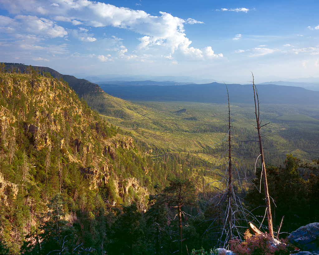
The Mogollon Rim is a 2,000-foot wall of limestone and sandstone running across central Arizona, with ponderosa forest on top and hot, rocky canyon country below. The race starts at the bottom east of Payson and runs point to point, east to west, to the little town of Pine. It goes up the Rim, back down, along the base on the Highline Trail, and back up, six times. Aravaipa lists it at about 101 miles and 15,900 feet of climbing, with nearly 9,000 of those feet in the first 40 miles. Grades hit 30-45% in places.
I ran it on September 6, 2025, and finished in 30:56:11, 39th overall. My COROS logged 104 miles and 15,866 feet of climbing. This guide has everything I'd want a friend to know before lining up: the aid stations and cutoffs, how a crew actually gets to each dirt-road crew zone, the climbs, the weather that turns this race upside down some years, and where it's decided. Official facts come from Aravaipa's 2026 runner guide, crew manual and cutoff chart (the 2027 guide isn't out yet). The personal parts come from my own race and my own watch data.
The race on one page
| Next race | Saturday, September 11, 2027, 6:00 AM (the 42K runs Sunday, Sept 12, 7:00 AM) |
| Start | Two-Sixty Trailhead on AZ-260, about 24 miles east of Payson. Drop-off only; runners take the race shuttle |
| Finish | Pine Community Center / Pine town ramada on AZ-87, Pine, AZ |
| Distance | About 101 miles (100.9 on the race page, 101.3 on the cutoff chart) |
| Climbing | 15,900 ft per the race stats. High point about 7,900 ft |
| Time limit | 38 hours (8:00 PM Sunday) |
| Entry | First come, first served on RaceGoat. $395 + fee ($419.31) until Jan 15, 2027, then $425 |
| To enter | A previous 50-mile or longer finish, plus 8 hours of trail work or volunteering (or a donation to a local trail group) |
| Qualifies for | Hardrock. Starting with 2026, also Western States. The 2027 status wasn't posted when I checked |
| Pacers | From Buck Springs, mile 43.1 |
| Crew | One vehicle per runner, at five zones plus the finish |
| Drop bags | Fish Hatchery (27.1), Buck Springs (43.1), Geronimo (71), finish |
| Finish rate | 2026: 141 of 248 (57%). 2025: 128 of 202 (63%). 2024: 106 of 175 (61%) |
| Official page | aravaiparunning.com/mogollon-monster |
Course records: Jeff Browning 20:52:07 (2021) and Megan Eckert 24:42:24 (2023). The 2026 winners were Andy Chrysler (21:26:35) and Moriah Carty (27:45:00).
Map and profile
Aravaipa publishes the 100-mile route on Strava and CalTopo. Load the GPX on your watch. The race guide says runners go off course every year, and some of the connectors (Horton, the bottom of Myrtle, Fred Haught) are easy to miss.
The CalTopo version is here: caltopo.com/m/MQNF393. For the official elevation profile, see the race page. Below is what the climbing looked like on my wrist, mile by mile:
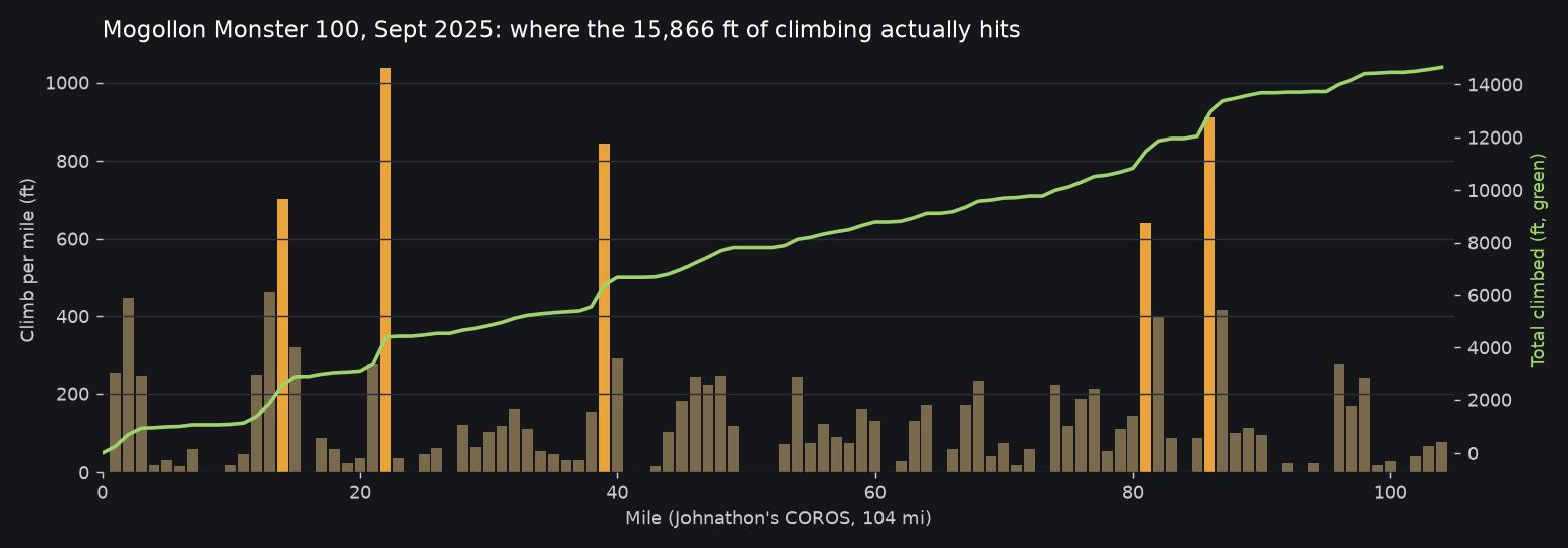
Chart: my own COROS data, Mogollon Monster 100, Sept 6, 2025. Each bar is one watch mile. The orange spikes are the Rim climbs. Per-mile splits add up a little under the watch's 15,866 ft total.
Look at the spikes: about 700 ft in watch mile 14 (See Canyon), 1,037 ft in mile 22 (the Horton climb), 843 in mile 39 (Myrtle), then a long break until 640 in mile 81 (Donahue) and 912 in mile 86 (Turkey Springs). The front half is all climbing. The back half saves its two meanest climbs for Sunday morning, after a night on the Highline.
The six climbs, one at a time
1. Two-Sixty to the Rim (miles 0-2). About 1,000 ft in 2 miles, fresh legs, cool morning. The race calls it the easiest climb, and it is. Then the General Crook and Drew trails along the top, and a short out-and-back into See Canyon.
2. See Canyon (about miles 11-14). About 1,700 ft back up, and that leg totals 3,750 ft of climbing to Horton. Then comes the steep, loose Promontory Butte descent through old burn and deadfall. It's the first place your quads find out what kind of day it is.
3. Horton Spring to the Rim (about miles 19-21.7). Short, steep switchbacks on a connector that's hard to see. This was my biggest climbing mile of the day. You top out on the Rim at about 7,900 ft at Horton Trailhead, then get about 3 miles of Rim Road running.
4. Myrtle (about miles 37-39.6). This is the one people talk about. You come off the Highline in the hottest part of the afternoon and climb an overgrown trail through waist-high grass that's hard to find at the bottom. The race guide tells the story of a runner who simply couldn't continue up Myrtle, and warns you not to be on it without a light.
5. Donahue (about miles 77-80). Short and punchy, on loose volcanic rock with manzanita and catclaw grabbing at you, on a hot Sunday morning, after you've been awake for 24 hours.
6. Turkey Springs (about miles 82-84). After the steep West Webber descent, an exposed, loose climb to the Dickerson Flat crew zone. Get to the top and the hard climbing is over.
And the descents matter just as much: Promontory Butte (around 15-17), the General Springs power-line drop off the Rim at mile 57 (roughly 45 degrees for the first quarter mile, big loose rock, usually in the dark), West Webber after Donahue, and Pine Canyon, which drops about 1,800 ft in 2 miles after mile 89.
Between climbs is the Highline Trail, the rocky, rolling route along the base of the Rim. An Aravaipa staff piece surveying first-time 100-mile finishers found that people thought the Highline's rocks and rollers were harder than the climbs. After running it, I believe them.
Every aid station (2026 official chart)
Cutoffs are leave-by times, built on about 22:30 per mile overall, from a 6:00 AM Saturday start. These are the 2026 numbers. Check the 2027 guide when it's published.
| # | Aid station | Mile | To next | Climb to next | Crew | Drop bag | Pacer | Leave by | Notes |
|---|---|---|---|---|---|---|---|---|---|
| 0 | Start, Two-Sixty TH | 0 | 11.1 | 1,100 ft | Drop-off only | Hand in bags | – | 6:00 AM Sat | Climb #1 right away |
| 1 | See Canyon | 11.1 | 10.6 | 3,750 ft | No | No | No | – | Climb #2, Promontory descent, Highline, Horton climb #3 |
| 2 | Horton Trailhead | 21.7 | 5.4 | 125 ft | No (no parking) | No | No | 2:15 PM | On top. 3 miles of Rim Road |
| – | Black Mesa crew zone | 21.7-24 | – | – | Yes | – | – | – | Rim Road pull-offs, no aid. Then down Babe Haught |
| 3 | Fish Hatchery | 27.1 | 12.5 | 1,950-2,950 ft* | No | Yes | No | 4:00 PM | Longest, hottest section next. Headlamp and shell in this bag |
| 4 | Myrtle | 39.6 | 3.5 | 135 ft | No | No | No | – | After climb #4 (Myrtle). Small aid. Forest road next |
| 5 | Buck Springs | 43.1 | 7.6 | 990 ft | Yes | Yes | First pickup | 10:00 PM | No cell. Cabin Loop trails start |
| 6 | Pinchot Cabin | 50.7 | 6.3 | 960 ft | No | No | No | 1:00 AM Sun | "No-drop" aid: extraction takes 2-3 hours |
| – | General Springs crew zone | 57 | 2.4 | 15 ft | Yes | – | Yes | – | Then the steep power-line descent |
| 7 | Washington Park | 59.4 | 11.6 | 1,400 ft | No | No | No | 4:15 AM | Eat real food. Long night on the Highline next |
| 8 | Geronimo | 71 | 9.5 | 2,200 ft | No (pacer drop/pickup only) | Yes | Yes | 8:30 AM | Highline, then climb #5 (Donahue). Leave with lots of water |
| 9 | Donahue | 80.5 | 3.8 | 1,800 ft | No | No | No | 12:15 PM | West Webber descent, climb #6 (Turkey Springs) |
| – | Dickerson Flat crew zone | 84.3 | 4.9 | 140 ft | Yes | – | Yes | – | Runnable Milk Ranch Point road next |
| 10 | Pine Canyon | 89.2 | 10.6 | 900 ft | No | No | No | 3:30 PM | 1,800 ft drop, then 10+ rolling miles |
| 11 | Pine Trailhead (water only) | 99.8 | 1.5 | 45 ft | Yes | No | Yes | – | Under AZ-87 through a culvert, then through town |
| F | Finish, Pine | 101.3 | – | – | Yes | Finish bag | – | 8:00 PM Sun | 38 hours |
*The chart says 1,950 ft from Fish Hatchery to Myrtle. The runner guide's text says about 2,950. Plan for the bigger number.
Drop bags: small bags only, labeled with bib, name and station, handed in at the start between 5:00 and 6:10 AM. Bags go back to Aravaipa's Phoenix warehouse and are held for 30 days, so you don't have to collect them in Pine.
Food: the race guide says to bring your own gels and anything special-diet. The aid stations are well stocked, but don't count on your exact brand being there.
What my splits looked like
My watch measured long (104 miles), so these are approximate times at each station, matched by distance. They give you an idea of how a mid-pack, 31-hour Mogollon goes:
| Station | Mile | My approximate elapsed time |
|---|---|---|
| Horton | 21.7 | ~5:00 |
| Fish Hatchery | 27.1 | ~6:30 |
| Buck Springs | 43.1 | ~11:20 |
| General Springs | 57 | ~15:30 |
| Geronimo | 71 | ~20:00 |
| Donahue | 80.5 | ~24:10 |
| Pine Canyon | 89.2 | ~27:15 |
| Finish | 101.3 | 30:56:11 (official) |
Two things stand out when I look back at it. First, Fish Hatchery to Buck Springs took me close to five hours for 16 miles. That's the heat and Myrtle, and it's where the race happens. Second, the last 30 miles took about 11 hours: Donahue, Turkey Springs and the long Pine Canyon stretch on Sunday morning. Runner Justin Poehnelt's published splits show the same pattern: Geronimo to the finish is the slowest part of the course relative to its distance. Plan your pacer, your food and your patience around that.
Crew guide: the Rim Road, dirt and no signal
This is a crew-hard race, and nobody should go in thinking otherwise. The crew zones are on Forest Service dirt roads on top of the Rim, with long drives, no services, and mostly no cell service. Read Aravaipa's 2026 crew manual the week before. The basics:
- One crew vehicle per runner, with the crew pass on the dash.
- Crew only at: Black Mesa (miles 21-24), Buck Springs (43.1), General Springs (57), Dickerson Flat (84.3), Pine Trailhead (99.8) and the finish. No crew at See Canyon, Horton, Fish Hatchery, Myrtle, Pinchot, Washington Park, Geronimo or Donahue.
- Roads: no 4x4 required. The crew manual says high clearance gives "more peace of mind." Expect washboard, hairpins, blind corners, OHVs, elk, and big drop-offs. Runners share some of the roads; drive slowly.
- No gas, food, water or toilets on the Rim. Last gas is in Pine, Payson, Star Valley or Forest Lakes (limited hours). Download offline Google Maps before you leave town.
- Cell signal is best near the edge of the Rim. There's none at Buck Springs, General Springs or Dickerson Flat. Wait at a pull-off where you have signal, watch live tracking, then drive in.
| Crew point | Runner mile | How to get there | Drive | Parking / signal |
|---|---|---|---|---|
| Start (Two-Sixty TH) | 0 | Runners take the race shuttle (about 4:25 and 4:40 AM) from the Old Pine parking area, about 1 mi south of Pine TH. About 45 min ride | ~45 min from Pine | Drop-off only, no parking |
| Black Mesa zone | 21.7-24 | AZ-260 up onto the Rim, then the Rim Road (FS-300) to the stretch between Horton Creek and Babe Haught trails (race pin) | Not listed in the manual. Allow an hour+ from Pine | Pull-offs only; don't block the road. Signal near the Rim edge |
| Buck Springs | 43.1 | Rim Road to FS-321, just over 3 mi to the aid on the right (race pin) | Not listed. From Black Mesa it's a Rim Road drive | Limited. Expect to walk up to 1/2 mile. No cell. Don't wait at Myrtle |
| General Springs zone | 57 | From Pine TH: AZ-87 north 14.5 mi, left on the Rim Road (FS-300) 12 mi to the power lines and the Battleground monument, then left down FS-705 to General Springs Cabin. Don't take FS-123 (race pin) | 32.5 mi, ~1 h 16 min from Pine (crew manual) | About 1/3 mi of road shoulder; runners are on the road. No cell at the cabin |
| Geronimo | 71 | Off AZ-87, 20-25 min (race pin) | 20-25 min | Pacer drop-off/pickup only, no parking, no crew. Don't drive into the Camp Geronimo scout camp |
| Dickerson Flat zone | 84.3 | AZ-87 north 14.5 mi to the Rim Road turnoff, go straight (not left), 1.2 mi to a Y, keep right, 1.7 mi to Turkey Springs TH on the left (race pin) | Not listed; plan ~40 min from Pine | Pull-offs and meadow near the TH. No cell |
| Pine Trailhead | 99.8 | Less than a mile from Pine, paved | ~5 min | Drop-off only |
| Finish | 101.3 | Pine Community Center on AZ-87 (race pin) | – | Street parking around the center. Signal in town |
How the crew day actually goes: drop the runner at the shuttle around 4:15 AM, get breakfast, then head up the Rim for Black Mesa (they arrive around 4-6 hours in). Then you have a long gap: the runner's next crew point is Buck Springs at mile 43, usually 5-7 hours later, late afternoon to evening. After Buck Springs, General Springs is late night. Then the crew can sleep: the next crew point is Dickerson Flat at mile 84, Sunday morning. That middle-of-the-night gap is the only real rest a crew gets.
Where crews help most: Buck Springs is the big one. It's your runner's first crew stop after the hardest section, usually at dusk, with the first pacer pickup and cold, dark miles ahead. Have warm layers, real food, a fresh headlamp and dry socks laid out before they arrive.
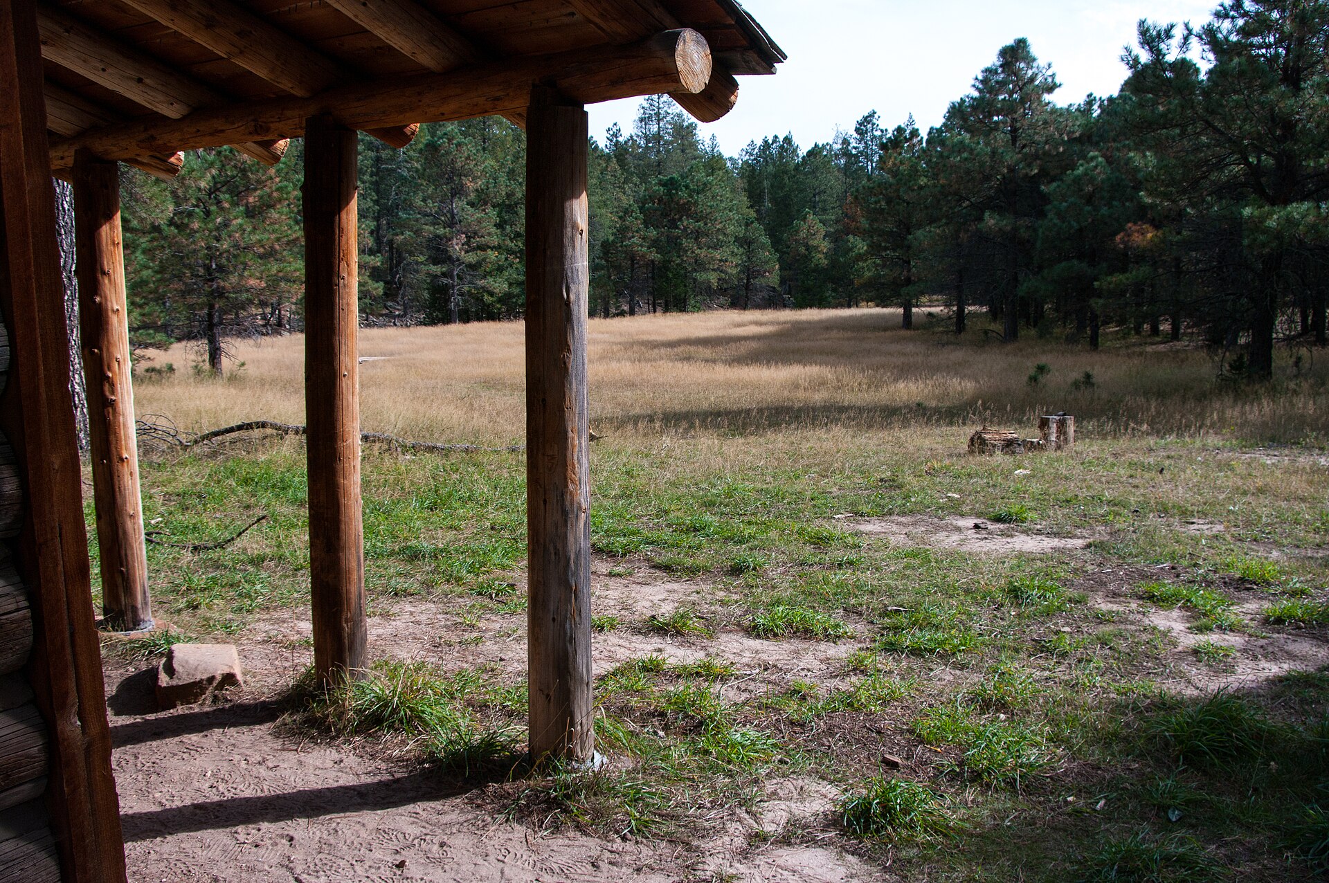
A crew on the Rim is basically car camping for 30 hours on Forest Service roads with no services. That's what a crew van is built for: a bed for the long night gap between General Springs and Dickerson Flat, a fridge so the cold drinks at Buck Springs are actually cold, a heater for 3 AM at 7,500 feet, and enough clearance that the Rim Road isn't stressful.
Pacers
- First pickup at Buck Springs (43.1). After that, pacers can join or leave at General Springs (57), Geronimo (71, drop-off and pickup only), Dickerson Flat (84.3) and Pine Trailhead (99.8).
- One at a time. No muling. Pacers get a bib and sign a waiver at the aid station or at packet pickup.
- The race materials I read don't list a minimum pacer age. Ask Aravaipa if you're planning on a teenager.
If you get one pacer: Buck Springs to General Springs (43-57) covers the first night. Geronimo or Dickerson Flat to the finish covers Sunday's climbs and the long Pine Canyon section, which is where my race slowed down the most. If you have two, split it at General Springs or Geronimo.
Where poles help
Poles are allowed, and you can leave them in or pick them up from drop bags. On this course I'd carry them from the start: climbs 1-3 come in the first 22 miles, and the Promontory descent alone justifies them.
- Start through Horton (0-21.7): three climbs, plus the loose Promontory descent.
- Myrtle (37-39.6): steep, overgrown, at the end of a hot afternoon. Poles very helpful.
- The power-line descent (57): steep, loose, in the dark. Poles help you brake.
- Donahue and Turkey Springs (77-84): loose rock, exposed, on tired legs. Poles very helpful.
- Pine Canyon descent (89+): 1,800 ft in two miles.
If you don't want them all day: put them in your Fish Hatchery bag for Myrtle, or have your crew hand them over at Buck Springs, and keep them through the Geronimo drop bag (71) for Donahue and Turkey Springs. Drop them with your crew at Dickerson Flat (84.3) only if your legs are still good for the Pine Canyon descent.
The finish line is decided here: Fish Hatchery to Buck Springs, miles 27-43
The race's own guide calls out Fish Hatchery to Myrtle as the critical section. It's 12.5 miles, the longest stretch between aid stations, at the hottest time of day, on the exposed Highline, with the Myrtle climb at the end. Runners show up at Myrtle and Buck Springs in bad shape, and that's where races get decided. From my watch, it was the slowest stretch of my first half.
Before Fish Hatchery:
- Don't race climbs 1-3. You're going to climb 9,000 ft by mile 40. Poehnelt's 2022 report is honest about going out with the front group for 40 miles and paying for it later.
- Run the forest-road sections. The race guide's advice: none are longer than 4.5 miles, and they're where you bank time against the cutoffs.
At Fish Hatchery (27.1):
- Carry at least two bottles, three if it's hot. The guide says one handheld won't be enough.
- Headlamp and shell go in this drop bag, because many runners reach Buck Springs after dark, and storms can roll in off the Rim.
- Ice or a wet buff if they have it, then leave.
Fish Hatchery to Myrtle (27-40): walk the hot rollers, eat every 30 minutes, soak in any water crossing, and remember that the climbing on the Highline tops out around 6,600 ft on exposed sandstone, which feels a lot hotter than the forecast for Pine.
At Buck Springs (43.1): crew, pacer, cold food. Chair rule: sit for five minutes, eat, change socks, put on warm layers and leave. Do not drop at Buck Springs because you had a bad afternoon. The sun's going down, the temperature is dropping fast, and the Cabin Loop trails are much kinder than the Highline.
And don't drop at Pinchot (50.7). The race calls it a no-drop aid. Getting you out takes 2-3 hours on Forest Service roads. Keep moving to General Springs, where your crew is.
The second low point is the Highline at night (59-71). Washington Park to Geronimo is 11.6 miles of rolling, rocky trail in the dark, usually between midnight and 4 AM. Eat a real meal at Washington Park and bring more food than you think you need. This is a "just get to Geronimo" section. Don't try to solve the whole race.
Get out of Dickerson Flat (84.3) and you're finishing. The climbing is done. From there it's the runnable Milk Ranch Point road, the drop into Pine Canyon, and 10 rolling miles home. Pine Canyon is long (it took longer than I expected), but you've got hours on the cutoff. Fill up at Pine Canyon aid and walk out of it eating.
Weather plan: the guide's line is that the Rim behaves more like a 12,000-ft peak than a 7,500-ft one. Mid-September in Pine averages 82°F by day and 42°F at night. Up on the Rim, plan for 10-15° colder, with lows of 30-35°F possible. Monsoon storms with hail and lightning hit the race in 2014 (the race was stopped at halfway), 2022, 2024 and 2025. In 2024 about 25 runners sheltered at Fish Hatchery. If a ravine crossing is running, wait for it to drop. Have a rain shell with you, not in your drop bag.
Stomach: GI trouble is the most common problem first-timers mention in Aravaipa's survey. Train eating on hot, hilly long runs. Poehnelt's glucose-monitor data from 2022 showed his low moods matched his blood sugar crashes, which is a good argument for small, constant calories.
What crews should say at Buck Springs: "The hard part is behind you. It's cooler from here on." It's true.
What runners say (the stuff that isn't on the race page)
There isn't much Mogollon Monster discussion on Reddit, so most of this comes from finishers' blogs, Aravaipa's own write-ups and my race.
- Navigation is part of the race. Runners go off course every year. Watch for the Horton connector, the bottom of Myrtle (overgrown), Fred Haught's turns and the Bear Canyon crossing. Load the GPX.
- If you step off the trail for a bathroom stop, the race asks you to leave something on the trail so the sweeps know you're there.
- Don't cut switchbacks. It's a penalty or a DQ, and it's Forest Service land.
- Point-to-point is easier mentally than loops. That came up in Aravaipa's first-100 survey, and I agree: you're always going somewhere new.
- Heat lingers. Poehnelt's 2021 report says it took hours to rehydrate after the below-Rim sections. Drink before you're thirsty on the Highline.
- Buck Springs is a lively aid station (the race guide mentions chili). It's a good place for real food before the night.
Video reports worth watching before race day:
More: Aravaipa's short film New Hardest Thing, the official 2026 race brief, and runner reports from Back of the pack ultra guy and Simon. Written reports: Justin Poehnelt 2021 and 2022, and Aravaipa's first-100 survey. Race photos are in Aravaipa's galleries: 2026 and 2025.
Gear and packing list for the Rim
Picks for this course specifically. These are Amazon affiliate links; AZ Ultra Adventure earns a small commission if you buy, at no extra cost to you.
- Trekking poles. Six climbs and four steep descents. Folding carbon trail poles that stow on your vest.
- A vest with real capacity. You need 2-3 bottles for Fish Hatchery to Myrtle, plus a shell and a light. A 12L running vest works better here than a minimal one.
- Soft flasks. An extra pair of 500 ml soft flasks for the 12.5-mile section.
- Headlamp with a long burn time, plus a backup. Most people spend 10-12 hours in the dark. A rechargeable trail headlamp and a small waist light for depth on the rocky Highline.
- A real rain shell. Monsoon hail has hit three of the last four years. A packable waterproof running jacket.
- Warm layers for the Rim at night. Light running gloves and a thin beanie in your Buck Springs bag.
- Gaiters. The Highline's decomposed granite and Myrtle's grass seeds get in everywhere. Short trail gaiters.
- Anti-chafe. A stick of anti-chafe balm for 30 hours of sweat and rain.
- Electrolytes. Electrolyte capsules for the hot below-Rim sections.
- For the crew. Folding camp chairs, a portable power station to charge watches and phones with no services, and a paper map of the Coconino/Tonto Rim area for when there's no signal.
The van idea: a base camp on the Rim
Of all the races I've run, Mogollon is the one where a crew most needs a home base. Everything a crew does here is harder without one: no services for 30 hours, cold nights at 7,500 feet, long gaps between crew zones, and a point-to-point finish in a small town an hour from where you started. An AZ Ultra Van is meant to be that base: bed, fridge, ice, heat, shade, power, and compression boots for the runner in Pine on Sunday afternoon.
We're testing demand with a reservation-interest list, and nothing is guaranteed yet. If you'd use one for Mogollon, the card in the crew section above is how to tell us.
Mogollon Monster FAQ
When is the 2027 Mogollon Monster 100? Saturday, September 11, 2027, starting at 6:00 AM at Two-Sixty Trailhead east of Payson, with a 38-hour limit (8:00 PM Sunday) at the finish in Pine. The 42K is Sunday, September 12.
How hard is the Mogollon Monster 100? About 101 miles and 15,900 ft of climbing, with six climbs up the Rim and grades up to 30-45%. Finish rates were 61% (2024), 63% (2025) and 57% (2026). It's one of the hardest 100s in Arizona, and the Highline's rock is a big part of why.
How do I get in? Is there a lottery? No lottery. Registration is first come, first served on RaceGoat. You need a previous 50-mile (or longer) finish and 8 hours of trail work or volunteering.
Is Mogollon Monster a Western States or Hardrock qualifier? The race page lists it as a Hardrock qualifier and, starting with the 2026 race, a Western States qualifier. Confirm the 2027 edition on wser.org and hardrock100.com before you count on it.
Where can crews meet runners? Black Mesa (miles 21-24), Buck Springs (43.1), General Springs (57), Dickerson Flat (84.3), Pine Trailhead (99.8) and the finish. One vehicle per runner. The roads are dirt; high clearance helps but 4x4 isn't required.
When can I pick up a pacer? Starting at Buck Springs, mile 43.1. Then at General Springs, Geronimo (drop-off and pickup only), Dickerson Flat and Pine Trailhead.
What's the weather like? Usually warm to hot during the day below the Rim (low 80s in Pine, hotter on exposed sandstone) and cold at night on top (30s to 40s). Monsoon thunderstorms with hail and lightning are common enough that you should always carry a shell.
Is Mogollon Monster good for a first 100? It's hard, but people do it. Aravaipa surveyed first-time finishers who said yes: hiking the climbs is expected, the 38-hour limit is generous, and point-to-point keeps your head in it. Train on steep climbs, practice eating in the heat, and respect the Highline.
Who wrote this
Johnathon Lawson is a Gilbert, Arizona ultrarunner, middle school track and cross-country coach, and father of three. He finished the Mogollon Monster 100 on September 6, 2025 in 30:56:11, and has also finished Zion 100 (2025) and San Diego 100 (2026, 28:37). Follow his training on Strava, see his race history on UltraSignup, and find AZ Ultra Adventure on YouTube and Instagram. Also read our San Diego 100 guide.
Sources: Aravaipa Running, Mogollon Monster race page (2027 date, stats, records, qualifiers), 2026 runner guide, 2026 crew manual and cutoff chart; RaceGoat registration and results; Johnathon's COROS data from the 2025 race; reports linked above. 2027 cutoffs and crew rules may change. Check the race's current runner guide during race week.
Some links are Amazon affiliate links. As an Amazon Associate we earn from qualifying purchases, at no extra cost to you.